|
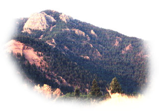
Blodgett Peak and the Wreck 9423 foot peak From trailhead to top: 3 miles (6 mile round trip) From trailhead to top: 2463 foot rise from trailhead to peak View Trail Map Click on pictures to enlarge |
| We began around 7:00 am, starting at the trailhead of Trail 713 just outside the McCullough Water Treatment Plant in Pine Valley on the US Air Force Academy grounds. The sun had risen over an hour ago and the air was still cool. The sun however, promised a hot day. We had to be careful, because it was easy to get off Trail 713 at the beginning since the sign directing you to Trail 713 from the Falcon Trail had fallen and was hard to see in the surrounding brush. We found the trail quickly, however, and easily found the other Trail 713 signs. The trail opened into a meadow-like area with tall golden grasses similar to wheat. | A stiff cool breeze greeted us as the trail climbed and headed southwest. We soon left the open grassland and found ourselves surrounded by scrub oak. The trail was easy to follow. It was more a jeep road than anything else. At the start we could see Blodgett. It challenged us and stood as our beacon while we followed Trail 713 onto the Water Treatment Plant grounds. After rising through the open areas of golden grass at the beginning, the trail leveled off in t he scrub oak and turned south. Walking through the scrub oak we came upon another open area and found a nice surprise. |
|
|
|

|
Silhouetted by the backdrop of Blodgett Peak was a buck muledeer and three young females. The females quickly bounded off when we happened upon them, but the young buck stood and stared at us. He posed for a while, allowing Scott to snap a couple pictures, one with Blodgett in the background (shown above) and a closer shot (shown to the left). We stood for about a minute staring at each other before he too bounded off in the brush never to be seen by us again. |
|
|
|
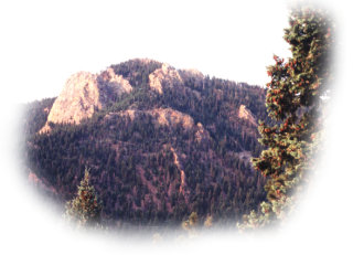
| We continued on Trail 713, heading southwesterly and admired Blodgett Peak again. Hiking deeper into the water treatment facility grounds, the trail turned west and then south and passed the east side of the Tesla Hydroelectric Plant. The trail followed a paved road downwards (how we dreaded losing the little elevation we had gained already!) and then met with Monument Creek. At a fence blocking us from taking the washed out Aqueduct, we hiked up a steep and rocky incline westward. The steep incline seemed to go on forever. Just when you thought it might level off, it didn't. When it eventually did level off, we walked through the shade of many pine trees and the coolness quickly dried the sweat we had accumulated during the steep climb. Finally, the trail met with the Aqueduct that ran along Monument Creek. We stayed on the Aqueduct until we came across a large water holding tank. At this point we left Trail 713 and turned south across a short footbridge and on to Blodgett Peak. We could have stayed on the Aqueduct and hiked to Northfield Reservior and Rampart Reservior beyond that. We'll leave those for another day. |
|
|
|
|
|
After crossing the footbridge, we hiked past the water tank and crossed a small stream. We then climbed up the ridge, heading southeast. The incline was long, steep, and full of loose dirt. Sweat started flowing again and we were happy to get up to the top of this particular ridge. We passed a tall group of rocks. Of course we had to climb up and get a look at the view. It was beautiful, but we had a lot of territory to cover yet before we got to the top of Blodgett. We pressed on, our appetite whetted by the views from the high rocks. The ridge climbed some more and just when we thought we couldn't climb anymore, the ridge leveled out and we could see the "Wreck" below and to the left of us (east side of the mountain). |
|
|
|
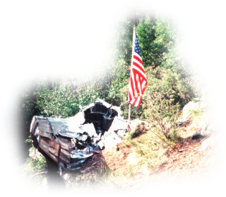
| On Feb 23rd, 1943, a twin-engined transport known as a C-49J was enroute from Pueblo to Denver. The pilot and two crewmen were flying in overcast weather. The plane crashed at 1205 hours local time, killing the entire crew. The official record from the War Department offers no explanation for the crash. The reason for the crash was listed as Collision - Other Object. A US Flag and small placard were placed at the portion of wreckage highest on the slope in 1999. As we got closer, we saw that the memorial had been placed by the ALS Class of 1999. This was an appropriate memorial for a crew that was almost forgotten in a crash that happened during a time when our country was involved in a spectacular struggle for the fate of the world. Looking on the small memorial, we realized the effort the creators had put forth to get the flag and placard up here. It was tough climb without a flag and placard! The flag has faded a bit from months in the bright Colorado sun, and the placard is a bit weather-worn, but it is a fitting tribute to our fallen comrades. |

|
|
|
|
|
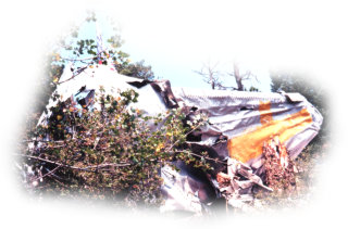
We climbed down the scree of the mountain-side to get a closer look at the wreckage. Looking up, we saw a large yellow cross painted on what appeared to be the vertical tail of the plane. We explored a bit, being careful not to disturb the wreckage. It was tough climbing back up the scree, but there were enough roots and trees to allow us to get back to the ridge without too much trouble. Once on the ridge, we had another steep slope to climb! This was getting ridiculous, but the end was in sight and we knew it. We had to go over another large group of rocks before another steep slope and the final scramble over boulders to the top of Blodgett Peak. |
|
|
|
| When we finally reached the top, we realized the sweat and heavy breathing to reach this was all worth it! My what views. The first view to greet us was when we looked back to see the Cadet Area of the Air Force Academy below us. It was easy to pick out the distinctive Cadet Chapel. |

|
|
|
|

|
We made it! To the west we saw Pike's Peak and it was beautiful. Below us we could see just how far we had come and could barely make out our car at the trailhead. Colorado Springs lay before us and we saw everything from Falcon Stadium to the airfield. |
|
|
|
| Despite all the scenery to look at, our eyes were constantly drawn to Pike's Peak. She beckoned us and we heard her siren's call. Now we had to conquer her. She was voluptuos and harsh. She had treasures you yearned to pick, but you would have to pay the price, oh yes. As we headed down Blodgett Peak the way we had come, our thoughts were on her. Despite being a mile higher than Blodgett, we thought Pike's Peak wouldn't be nearly as strenuous. The next day we found out just how wrong we were. It was comforting to know that the next day we would have more company on our hike to conquer Pike's Peak. We were energized and enthusiastic after Blodgett, even if a bit tired. We bouldered down Monument creek back to Trail 713 and back to the car. Pike's Peak would soon be ours! But at what price? |

|
|
|
|
Topo map of Blodgett Peak Area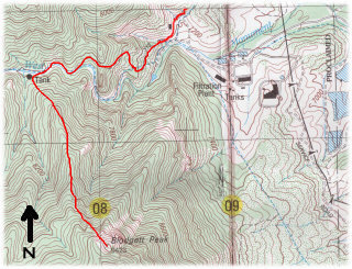 Topo map with trail to Blodgett Peak marked  |
|